
Chinese space threats are evolving fast—could the same research that makes satellites harder to find also make submarines easier to cue, sooner than most planners expect?
Chinese space threats: Can we see 500+ meters deep into the ocean from space?
That question sat under the surface at the Spacepower 2025 reporting by Breaking Defense, where U.S. Space Force (USSF) leaders described a shift from predictable orbital “stalking” to something closer to competitive concealment and rapid manoeuvre. Notably, the most interesting part is not one single gadget. Instead, it is the direction of travel across sensors, signatures, and non‑kinetic attack options.
Consequently, this article treats the underlying Chinese research as a roadmap. It focuses on what is being pursued, what has been demonstrated in public, and what science might enable in the near term, mid term, and long term. The goal is not hype. The goal is preparedness.
Chinese space threats: from “sanctuary” to contested orbit
Space Domain Awareness starts with the “unclassified” briefs
For years, USSF and industry have used unclassified threat briefs to push one message: space is no longer a quiet utilities layer. Instead, it is becoming a contested warfighting domain where intelligence, surveillance and reconnaissance (ISR) and command links can be disrupted, spoofed, or physically interfered with.
Notably, Chief Master Sergeant (CMSgt) Ron Lerch has repeatedly appeared in that briefing ecosystem. A public Space Force Association listing shows Lerch delivering a virtual “Space Warfighter Talk” on March 26, 2024. Meanwhile, Space Systems Command (SSC) imagery notes him providing a “Space Threats briefing” at an SSC and U.S. Space Command Reverse Industry Day on June 25–26, 2024.
Additionally, those venues matter because they anchor the conversation in observable behaviour, commercial tracking, and open‑literature research. In other words, the warning is not based on classified magic. It is based on patterns anyone serious can track.
As a practical aside, “unclassified” in this context is like “unarmed” in aviation security: it reduces friction, not consequences.
From cat-and-mouse to “hide and seek” in Low Earth orbit
The most quoted moment from Spacepower 2025 is also the most revealing. Lerch argued that the old dynamic in geosynchronous Earth orbit (GEO) is giving way to a different contest in low Earth orbit (LEO).
“In years past, we’ve talked about this cat and mouse game that was happening at GEO [geosynchronous Earth orbit] — Chinese, Russian, US satellite, sort of stalking each other. This past year has really been more of a hide and seek game that we’ve seen at LEO [low Earth orbit],” — CMSgt Ron Lerch, USSF, via Breaking Defense
However, “hide and seek” is not just rhetoric. It implies at least three concrete trends: smaller spacecraft, lower signatures, and more frequent manoeuvres. Moreover, it implies a future where “seeing first” becomes less reliable, even for advanced tracking networks.
Separately, Lerch also connected stealth shaping to measurable outcomes. “Not only are [some Chinese satellites] difficult to visually acquire, that shape, they believe, would be incredibly beneficial in terms of masses of the radar cross section,” — CMSgt Ron Lerch, USSF, via Breaking Defense
Even so, the deeper issue is strategic. Once “finding” gets harder, every defensive move costs more. Meanwhile, every offensive move can be plausibly deniable.
The numbers behind the mood shift
It is easy to dismiss warning language until you look at the scale. A USSF “Space Threat Fact Sheet,” current as of December 2025, says that as of November 2025 China had “more than 1,301 satellites in orbit.” Notably, it adds that the People’s Liberation Army (PLA) “benefits from 510+ ISR-capable satellites.” It also states: “By November 2025, China had conducted 70 total space launches this year, placing 319 payloads into orbit.”
Moreover, the fact sheet points to a dual‑use future where sensing, computing, and communications blend. It notes that in May 2025 China launched the first 12 satellites of its “Three‑Body Computing Constellation,” described as an artificial intelligence supercomputer array with a planned processing capacity of “one quintillion operations per second.” (USSF Space Threat Fact Sheet)
Consequently, the core story is not “China has a new toy.” The story is that Chinese space threats now sit on industrial scale. That scale changes timelines, survivability, and escalation risk.
To put it plainly: an adversary with a deep bench can treat satellites the way modern air forces treat unmanned aerial systems—expendable, replaceable, and tactically flexible.
Chinese space threats: LiDAR and the sensing race
Why Light Detection and Ranging matters in orbit
Light Detection and Ranging (LiDAR) does one thing exceptionally well: it turns time-of-flight into precision. In practical terms, LiDAR can produce extremely accurate range and shape information when geometry, pointing, and power budgets cooperate.
However, the key word is “shape.” In an orbital contest, shape is signature. Shape is intent. Shape can also be a weapon, if it enables proximity operations with tight tolerances.
Meanwhile, LiDAR complements radar and optical telescopes rather than replacing them. Radar offers all‑weather tracking and coarse characterisation. Optical offers fine detail under the right lighting. LiDAR offers active measurement, potentially with very high fidelity at close ranges.
As a light reality check, LiDAR does not need to map an entire satellite. It only needs to resolve enough geometry to classify, predict, and intercept. That is where Chinese space threats begin to look less like “science fiction” and more like a procurement plan.
In orbit, “laser tag” stops being a game the moment you add a tracking algorithm.
China is already flying sophisticated spaceborne lidar
China’s LiDAR work is not hypothetical. A peer‑reviewed paper in Atmospheric Measurement Techniques describes the Aerosol and Carbon Detection Lidar (ACDL) aboard the Daqi‑1 satellite. The authors write: “On 16 April 2022, China successfully launched the world’s first spaceborne high-spectral-resolution lidar … called the Aerosol and Carbon Detection Lidar (ACDL) … on board … Daqi‑1.” — Qiantao Liu et al., Atmospheric Measurement Techniques
Notably, the paper also states the ACDL “is expected to precisely detect the three-dimensional distribution of aerosol and cloud globally with high spatial–temporal resolutions.” — Liu et al., Atmospheric Measurement Techniques
Consequently, China is building real, flight‑qualified expertise in spaceborne lasers, calibration, pointing, and atmospheric correction. That is the unglamorous work that makes future dual‑use concepts plausible.
Additionally, there is a strategic implication for allied planners: “LiDAR” is not a single programme. It is a skill stack. Once a country can fly and validate one type, it can iterate to others.
What to expect next: near term, mid term, long term
Near term (2026–2028): expect more fused Space Domain Awareness (SDA) where AI-enabled classification improves faster than sensors do. Moreover, expect more on‑orbit experiments that look “civil” while exercising rendezvous, station‑keeping, and inspection.
Mid term (2028–2032): expect more directed-energy experiments aimed at dazzling or degrading sensors. The USSF fact sheet uses the terms People’s Liberation Army (PLA) and People’s Republic of China (PRC): “The PLA has multiple ground-based laser weapons able to disrupt, degrade, or damage satellite sensors.” It adds: “By the mid-to-late 2020s, the PRC could have higher-power systems able to damage satellite structures.” (USSF Space Threat Fact Sheet)
Long term (2032–2040+): expect a broader family of active sensing, including multi‑spectral laser systems and distributed apertures. Consequently, the strategic risk is not “one magical sensor.” It is that detection probability rises when constellations, AI, and active measurement work together.
Importantly, none of this requires breaking physics. It requires capital, iteration, and doctrine. China is investing in all three.
Chinese space threats: stealth microsatellites and co‑orbital pressure
Olive‑B: a research paper with operational implications
The Olive‑B test article matters because it signals intent. In public reporting, Lerch pointed to a Chinese research paper describing microsatellite stealth shaping and radar cross section reduction.
Specifically, a 2022 open‑access paper in Aerospace discusses microsatellite stealth design and radar cross section (RCS) performance, framing radar stealth as a central concern for microsatellites. “Satellite stealth technology can be divided into radar stealth … and it is especially important to design and analyze microsatellites with low radar cross section (RCS) shape ….” — He et al., Aerospace (MDPI)
Moreover, the paper includes a section titled “Olive‑B Configuration Satellite Anechoic Chamber Test Verification,” describing test equipment inside an anechoic chamber. — He et al., Aerospace (MDPI)
Consequently, this is not merely a rumour about “stealth satellites.” It is a published design-and-test mindset aimed at reducing detectability. That mindset scales quickly once it meets commercial manufacturing.
In aerospace terms, this is the satellite equivalent of shaping a low‑observable airframe, then proving it in the lab.
“Dogfighting” in orbit and why it matters
In March 2025, USSF leaders described Chinese satellites manoeuvring in coordinated ways that resemble training for complex proximity operations.
“There are five different objects in space maneuvering in and out around each other, in synchronicity and in control. That’s what we call dogfighting in space.” — Gen. Michael Guetlein, USSF, via Breaking Defense
Separately, a report describing the same episode notes five satellites “maneuvering in and out and around each other in synchronicity and in control,” — Defense News
Notably, this is where “stealth microsatellites” and “LiDAR-like sensing” begin to converge. If a satellite can be harder to track, and it can also manoeuvre precisely, then proximity becomes a credible threat even without explosives.
As one dry observation: in orbit, “personal space” is measured in metres, not feelings.
Where co-orbital pressure could go next
Near term (2026–2028): co‑orbital systems will likely emphasise reversible effects. That includes sensor dazzling, jamming, shadowing, and close inspection. Importantly, reversible actions lower escalation thresholds.
Mid term (2028–2032): co‑orbital systems will likely add endurance and persistence. The USSF fact sheet says China “maneuvered two satellites, Shijan-21 (SJ-21) and Shijan-25 (SJ-25) into extremely close proximity where they conducted probable satellite refueling experiments in geosynchronous Earth Orbit (GEO).” (USSF Space Threat Fact Sheet) Longer‑lived “inspectors” become more practical when fuel and servicing improve.
Long term (2032–2040+): autonomy is the multiplier. Once manoeuvre planning, sensing, and decision loops become more autonomous, swarming and distributed interference become more plausible. Consequently, high‑value satellites will need active defence concepts, not just passive shielding.
Overall, Chinese space threats in this category are best understood as a continuum. It starts with better observation. It ends with selective denial of orbital services.
Counter‑LEO warfare and megaconstellation exposure
Why megaconstellations changed the strategic math
Megaconstellations made LEO more resilient and more politically complicated. On one hand, proliferated satellites can route around damage. On the other hand, they create dependencies on commercial governance, software updates, and corporate decision-making.
Meanwhile, China has drawn its own lessons from Ukraine and from the broader rise of commercial space. An Associated Press review found Chinese scientists have published dozens of papers in public journals exploring ways to counter Starlink, including non‑kinetic approaches. — Associated Press
Notably, the AP summary phrase is blunt: “Stealth submarines fitted with space-shooting lasers, supply-chain sabotage and custom-built attack satellites armed with ion thrusters.” — Associated Press
As a matter of tone, that is not a prediction of fielded capability tomorrow. It is a public description of the problem set Chinese analysts are modelling today.
To translate: Chinese space threats now explicitly include strategies for dismantling resilience, not just punching a single satellite.
What Chinese researchers are proposing in open literature
The AP reporting frames Starlink as a perceived national security risk, even though it does not operate inside China. Moreover, it highlights research that treats the constellation’s global coverage as a military factor rather than a commercial curiosity. — Associated Press
Separately, USSF public material supports the idea that non‑kinetic interference is central to modern planning. The fact sheet explicitly references the People’s Liberation Army (PLA) and states: “PLA military exercises regularly incorporate jammers against space-based communications, radars, and navigation systems like GPS.” (USSF Space Threat Fact Sheet)
Consequently, the most important shift is conceptual. Counter‑LEO warfare becomes an engineering contest over link budgets, encryption, beamforming, ground segment security, and recovery time. It also becomes a contest over attribution.
Additionally, the Chinese response includes building their own alternatives. The same AP reporting describes China accelerating its own megaconstellation projects such as Guowang and Qianfan. — Associated Press
In this space, the cynical joke writes itself: the best way to beat a constellation is to build your own, then argue about orbital slots later.
Near term, mid term, long term: how counter‑LEO scales
Near term (2026–2028): expect jamming and cyber operations to remain the most attractive tools. They can be local, reversible, and hard to attribute. Meanwhile, expect more “grey zone” pressure on supply chains, terminals, and software ecosystems.
Mid term (2028–2032): expect more directed-energy experiments aimed at dazzling or degrading sensors. The USSF fact sheet states: “The PLA has multiple ground-based laser weapons able to disrupt, degrade, or damage satellite sensors. By the mid-to-late 2020s, the PRC could have higher-power systems able to damage satellite structures.” (USSF Space Threat Fact Sheet)
Long term (2032–2040+): expect combined approaches. A future campaign could blend cyber intrusion, optical interference, and co‑orbital pressure into a coordinated denial strategy. Consequently, resilience will depend as much on operations and governance as on hardware.
Overall, this is where Chinese space threats connect directly to the aviation and aerospace industrial base. Every satellite depends on launch cadence, ground networks, and secure manufacturing.
Oceans, submarines, and space‑enabled cueing
Why the future might not require “seeing” through seawater
This is the section where tone matters most. People understand what cannot be done today. The more useful question is what future systems could infer, even if direct imaging remains rare.
Notably, the ocean is not an opaque black box. It is a complex signal environment. Consequently, a detection system can work by exploiting correlations: wakes, turbulence, internal waves, thermal anomalies, and magnetic disturbances. In practice, that means satellites might help narrow search areas, cue aircraft and ships, and compress the time between “maybe” and “track.”
Meanwhile, the playbook already exists in other domains. Modern ISR often works by fusing imperfect clues until the probability spike becomes actionable. That is not magic. It is statistics, persistence, and good tasking.
Put differently: the submarine may remain hidden, yet the ocean around it can still talk.
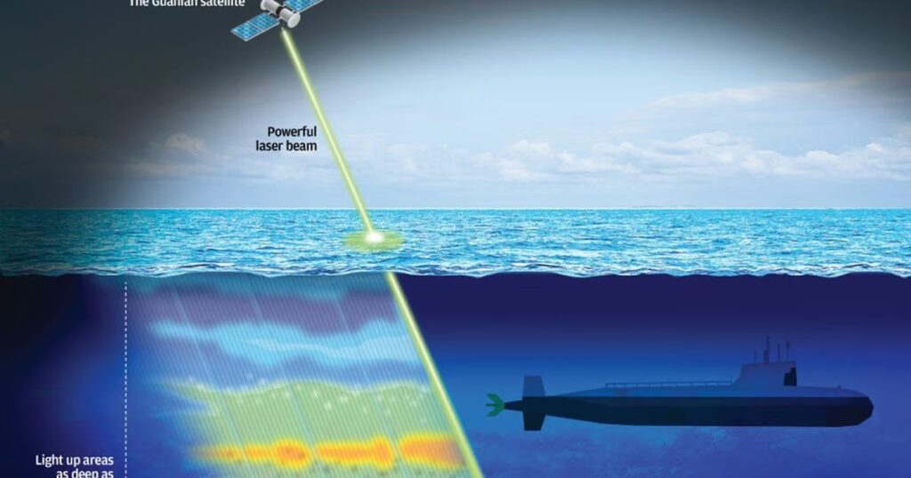
Project Guanlan and the blue‑green laser ambition
China’s most provocative open narrative about submarines and lasers comes from reporting on “Guanlan” (“Sea Watcher”), a project described as aiming for a laser satellite that could push light deeper into the sea.
In an October 4, 2019 report, the Australian Broadcasting Corporation (ABC) said Shanghai‑based scientists claimed a tested laser could reach “160 metres below the sea surface.” — ABC News
Moreover, ABC reported the same team was linked to the Guanlan project, which “aims to build a laser satellite” with a beam reaching “500 metres below the sea surface,” and that the programme was launched in May 2018 with “over 20 research institutes and universities” involved.
However, ABC also captured the core technical caution. “If you’re thinking about space-based systems then the challenges mount exponentially — it’s not really easy to do this,” — Manabrata Guha, researcher in war theory, UNSW Canberra, via ABC News
Consequently, the most responsible interpretation is this: China is working the problem in public, and it is willing to signal intent. Even if the 500‑metre claim remains aspirational, the research direction is strategically disruptive.
As a small comfort, seawater remains a brutal test range. As a larger concern, brutal test ranges have never stopped determined engineers for long.
From wakes to signatures: radar, optics, and AI fusion
While lasers attract headlines, other sensing paths may arrive sooner. Synthetic aperture radar (SAR) can image sea states and wakes in all weather, day or night. Meanwhile, optical systems can detect surface anomalies under the right lighting and sea conditions.
Additionally, research continues into modelling how a submerged body can generate surface patterns. For example, a 2024 paper titled “Echo‑Level SAR Imaging Simulation of Wakes Excited by a Submerged Body” explores wake imaging in a radar context. — Sensors (MDPI)
Notably, none of these approaches need to “see” a deep submarine. They need to detect a statistically meaningful disturbance, then hand off to aircraft, surface combatants, and undersea sensors.
That handoff is where aerospace becomes central. Airborne maritime patrol aircraft, long‑range uncrewed systems, and multi‑sensor ISR jets remain the tools that turn “cue” into “contact.” For context on how quickly airborne ISR architectures are evolving, see Fliegerfaust’s coverage of the US Army’s High Accuracy Detection and Exploitation System (HADES) Global 6500 plan.
In operational terms, satellites may become the wide‑area tripwire. Aircraft may remain the closer‑in investigator. The sea, unfortunately, gets no vote.
Near term, mid term, long term: what “ocean scanning” could become
Near term (2026–2028): the most plausible gains come from better cueing, not “x‑ray vision.” Expect more persistent maritime surface tracking from space. Assume faster AI‑assisted tasking. Expect more automated anomaly detection that flags “unusual wake behaviour” for follow‑up.
Mid term (2028–2032): expect more multi‑sensor constellations designed for maritime surveillance and targeting support. If China continues to grow its ISR fleet, it can pair SAR, optical, and electronic intelligence in ways that compress decision cycles. In that future, Chinese space threats could erode the value of “hiding in plain ocean,” especially in constrained waters and choke points.
Long term (2032–2040+): the Guanlan‑style laser ambition becomes more interesting, even if the most dramatic depth claims remain out of reach. A spaceborne laser that reliably probes tens of metres in clear water could still be operationally meaningful. It could help detect periscopes, masts, bubble plumes, or near‑surface disturbances that older sensors miss.
Consequently, the submarine problem may evolve into a “where and when” problem. That is, the undersea platform stays stealthy. Yet the window for transit, communication, and periscope‑depth operations may shrink.
Resilience and deterrence: what aerospace should watch next
Tactically Responsive Space is becoming a real operational muscle
The allied response is not static defence. It is resilience: more satellites, faster replacement, and more integration with commercial capability.
On February 20, 2024, the USSF published a detailed account of VICTUS NOX, describing it as a new standard for Tactically Responsive Space (TacRS). — United States Space Force
Notably, the same article describes a rapid call‑up and launch readiness goal: “The Launch Phase met its goal of being ready for launch within 24 hours, with liftoff taking place at the first available launch window, 27 hours after receipt of the launch order.” — United States Space Force
Moreover, the article quotes USSF Chief of Space Operations Gen. Chance Saltzman: “From the warehouse to on-orbit capability in a week. That’s tactically responsive,” — Gen. Chance Saltzman, USSF, via spaceforce.mil
Consequently, counterspace deterrence becomes less about preventing every attack and more about making attacks strategically pointless.
In the bluntest terms, the best armour sometimes is a spare part—delivered quickly.
Hardening is technical, but deterrence is behavioural
Resilience alone is not enough. If Chinese space threats increase pressure through reversible interference, governments will need clearer thresholds and better attribution pathways.
Meanwhile, commercial tracking and warning pipelines will matter more. SSC has also promoted an “Orbital Watch” concept to share threat information with industry and allies. — Space Systems Command
Additionally, the most practical near‑term work may be boring: cyber hardening, supply chain assurance, terminal security, and operational training to fight through degradation.
That may not headline well. However, it is the difference between a nuisance event and a strategic outage.
Where Canada and allies fit in: air, space, and the connective tissue
Canada’s aerospace ecosystem sits at the junction of business jets, ISR platforms, and allied integration. That matters because future resilience is multi‑domain. Satellites provide reach. Aircraft provide persistence, adaptability, and rapid sensor re‑tasking.
For example, Fliegerfaust has covered how connectivity and battle management concepts move onto business-jet class aircraft, including the US Air Force’s Battlefield Airborne Communications Node (BACN) Northrop Grumman Bombardier Global 6000/6500 pathway. Likewise, the site has tracked Bombardier Global 6500‑based early warning and surveillance developments, including France’s Saab GlobalEye order.
Consequently, the aerospace industry response is not only about “more satellites.” It is also about better airborne‑space integration, better data fusion, and faster decision cycles under attack.
As one final wry note: in modern conflict, “disconnect” is a weapon, and reconnecting is the counter‑weapon.
Conclusion
Chinese space threats are not a single breakthrough waiting to happen. They are a portfolio approach: improve sensing, reduce signatures, practise proximity, and explore non‑kinetic ways to degrade networks. Moreover, the same research culture that enables stealth microsatellites also enables ambitious cross‑domain ideas, including space‑enabled maritime cueing.
Crucially, the submarine angle should not be dismissed as fantasy, nor accepted as destiny. Instead, it should be treated as an indicator of intent. China is openly working on ways to make the upper ocean more transparent, and it is simultaneously scaling the space systems that would make any future “cueing” architecture viable.
My critical view is this: Western governments still talk about space resilience like it is a procurement choice. In reality, it is becoming a requirement for credible deterrence—and delay carries compound interest.
So here is the uncomfortable question to end on: if Chinese space threats keep compressing warning time in orbit and at sea, will allied doctrine and acquisition move fast enough to keep the advantage where it still matters?
Leave your answers and comments below and on our Fliegerfaust Facebook page.
Chinese space threats – Sources
- Breaking Defense — China, Russia experiment with stealthy satellites, Space Force official says (December 11, 2025).
- United States Space Force — USSF successfully concludes VICTUS NOX Tactically Responsive Space mission (February 20, 2024).
- United States Space Force — Space Threat Fact Sheet (December 2025).
- Breaking Defense — 5 Chinese satellites practiced “dogfighting” in space, Space Force says (March 18, 2025).
- Defense News — China demonstrated “satellite dogfighting,” Space Force general says (March 18, 2025).
- Associated Press — Chinese researchers suggest lasers and sabotage to counter Musk’s Starlink satellites (July 31, 2025).
- Atmospheric Measurement Techniques — Validation of initial observation from the first spaceborne high-spectral-resolution lidar with a ground-based lidar network (March 7, 2024).
- Aerospace (MDPI) — Stealthy Configuration Optimization Design and RCS Characteristics Study of Microsatellite (December 12, 2022).
- ABC News — China has tested a new laser designed to find submarines. This is how it works (October 4, 2019).
- Sensors (MDPI) — Echo-Level SAR Imaging Simulation of Wakes Excited by a Submerged Body (February 7, 2024).
- Space Systems Command — SSC launches Orbital Watch (April 10, 2025).
- Space Force Association — Space Warfighter Talk with CMSgt. Ron Lerch (March 26, 2024).
- Space Systems Command — Facilitating Intelligent Conversations About Artificial Intelligence (July 22, 2024).
For full details, please refer to our Disclaimer page.