
MH370 search resumes—so what, exactly, is happening now, and what would count as real progress in the world’s most scrutinised aviation search?
Nearly 12 years after Malaysia Airlines Flight MH370 vanished on March 8, 2014, the hunt is back in motion, again centred on the southern Indian Ocean and again driven by the same core promise: better tools, better targeting, and a narrower, higher‑probability box than the vast ocean that swallowed the evidence. This latest attempt is being conducted by Ocean Infinity under a “no find, no fee” arrangement announced by Malaysia’s government, with a defined seabed search window beginning December 30, 2025 and running intermittently for up to 55 days. On paper, that is a short mission. In practice, it is the kind of mission where each slow line on a ship‑tracking map carries a decade of expectation.
Meanwhile, the public can do something that almost never applies to accident investigations: watch the search unfold in near‑real time. A tracking page maintained by independent researchers claims Ocean Infinity’s “Armada 86‑05” has been moving into a defined search zone, and it even cites a proposed centre point around 35.7°S, 93°E.
At the same time, a January 5, 2026 report on Airlive notes “very low speed” movement in a “very specific area,” prompting online speculation about close‑in inspection work. Even so, the only hard truth remains unchanged: until imagery and identification confirm wreckage, every trackline is just a trackline.
MH370 search resumes: What Malaysia and Ocean Infinity confirmed
Renewed MH370 search: the December 30, 2025 start line
The clearest signal that this mission is real came from a government statement, not from social media. On December 3, 2025, Malaysia’s Ministry of Transport announced the resumption of the MH370 seabed search by Ocean Infinity in the southern Indian Ocean, with operations set to begin on December 30, 2025. That date matters because it aligns with the seasonal realities of the region, where sea states can shut down deployment and recovery cycles for sub‑surface systems.
Moreover, Reuters reported that the operation was planned as a 55‑day search beginning December 30. That “55 days” framing is an important nuance for readers. It implies an operational window, not necessarily 55 continuous days of survey lines.
However, the public still has limited visibility on the exact daily tempo. Ocean searches are often described in calendar days because that is how contracts, weather, and port calls are managed. Yet the real progress metric is kilometres of seabed scanned at the required sensor resolution and confidence level.
Ocean Infinity MH370 search: the contract terms and the targeted box
Separately, Associated Press reporting described Malaysia’s deal as a “no find, no fee” contract in which Ocean Infinity would receive US$70 million only if the wreckage is located, with the company proposing to search a new 15,000‑square‑kilometre area. That scale is worth pausing on. It is large enough to require disciplined survey planning and robust quality control. At the same time, it is far smaller than the early years of the underwater effort.
Consequently, this mission is being framed as targeted rather than exploratory. In practical terms, “targeted” usually means the search area has been refined by modelling and evidence synthesis, rather than by simple expansion.
Additionally, the new seabed box sits within a lineage of analysis that has been iterated for years by official bodies and independent teams. The Australian Transport Safety Bureau (ATSB) has consistently described the underwater search area definition as rooted in satellite communications (SATCOM) metadata analysis, end‑of‑flight modelling, and subsequent drift work on recovered debris. The ATSB’s MH370 search overview remains one of the most compact official summaries of how that reasoning developed.
While MH370 search resumes, still, contract terms do not guarantee transparency. A “no find, no fee” arrangement reduces public financial risk, but it can also reduce public reporting if commercial sensitivities dominate updates.
What changed since the 2025 pause
Meanwhile, this is not the first attempt to restart the search in recent years. In March 2025, Reuters reported Malaysia had reached an agreement with Ocean Infinity to resume the hunt, after the cabinet approved the plan in principle and after Ocean Infinity had conducted a previous private effort in 2018. That March 2025 reporting framed the deal as a “no find, no fee” arrangement, pending contractual details.
However, even as MH370 search resumes, the sea has veto power. On April 3, 2025, Reuters reported Malaysia’s transport minister said the search had been suspended and would resume later because it was not the season. That is the underlying operational logic behind the December 30 restart: the southern Indian Ocean is a harsh workplace in winter.
Notably, this seasonality is not a footnote. It shapes whether a mission can run autonomous underwater vehicle (AUV) and remotely operated vehicle (ROV) operations safely. It also affects navigation stability and system recovery without damage.
MH370 search resumes: Where the ship is working and why it matters
MH370 hunt restarts: public tracking, private uncertainty
Meanwhile, the most visible part of this mission is not sonar or robotics. It is an icon on a map. The independent website MH370‑CAPTION’s Armada tracking page states bluntly: “The search resumed on 30 December.” It also says Ocean Infinity’s “Armada 86‑05” was en route to a search zone presented in March 2024 during the 10th anniversary ceremony, and it references a recommended zone “centered on 35.7°S and 93°E.”
Track the Armada 86-05 live here: https://www.mh370-caption.net/index.php/armada-tracking/
Consequently, readers can place the new search in a geographic frame, even without official daily briefings. That is unusual in deep‑sea work. It is also a double‑edged sword.
However, public tracking can encourage over‑interpretation. A ship can slow down for many reasons, including sea state, equipment handling, or simply waiting for a sub‑surface cycle to complete. Conversely, a ship can steam quickly while autonomous systems do the actual survey work.
A gentle reminder belongs here: interpreting a vessel track without the operations log is like judging an approach by the contrails—interesting, but not decisive.
What “low speed in a specific area” could mean
Notably, Airlive’s January 5, 2026 report highlights “very low speed” movement in “a very specific area” and calls that behaviour “unusual” versus standard search patterns. The article explicitly links this observation to an online video discussion and frames the idea as a possibility, not as confirmation.
Moreover, the logic described is recognisable to anyone who has watched subsea survey work: deploy autonomous systems to cover broad strips, then return for closer inspection when the data produces a promising contact. Airlive’s description contrasts autonomous underwater vehicles (AUVs), which can follow pre‑programmed paths, with a remotely operated vehicle (ROV), which is tethered and controlled in real time.
However, the key word remains “could.” Without an official statement, the public cannot know whether a low‑speed loiter indicates ROV inspection, recovery of an AUV, calibration work, equipment troubleshooting, or a wait for sea conditions.
Additionally, the Airlive piece mentions a cycle timing interpretation: it suggests the ship passed through a sector on December 30 and returned roughly four to five days later. That timing may or may not match the mission’s actual system endurance and handling procedures, which vary by platform and payload.
Consequently, the responsible position is to treat the tracking as a clue about activity, not a clue about discovery.
Why location still matters: the 7th arc and the “new box” logic
Separately, it is worth explaining why a coordinate like 35.7°S, 93°E attracts attention at all. Officially, the ATSB has described the underwater search area definition as anchored in the final SATCOM transmissions and the resulting “arc of possible aircraft positions.” In its First Principles Review, the ATSB explains that the “7th arc” is the arc of possible positions, equidistant from the Inmarsat Indian Ocean Region satellite, where the aircraft made the final series of transmissions.
Moreover, the ATSB’s 2016 First Principles Review states that “the updated independent analysis … identified the most likely impact location … close to the 7th arc” and bounded roughly between 33°S and 36°S. — Australian Transport Safety Bureau, MH370 – First Principles Review
Consequently, any new mission that concentrates in that latitude band is not starting from zero. It is acting on a decade of probabilistic narrowing.
However, probability is not a guarantee. A “high probability” box can still be empty if the underlying assumptions are wrong, if the aircraft’s end‑of‑flight behaviour differed from the modelled scenarios, or if the debris field dispersed in unexpected ways.
MH370 search resumes: The technology—AUVs, sonar, and deep‑ocean realities
MH370 wreckage search: why the seabed is both searchable and brutal
Notably, deep‑sea aviation recovery is a solved problem only when the search box is small. In the MH370 case, the problem has never been the existence of technology. It has been the combination of remote ocean geography, extreme depths, complex seafloor terrain, and uncertainty about the final location.
Moreover, the ATSB’s First Principles Review describes how early planning for the underwater search aimed for equipment capable of detecting an object about 1 m × 1 m × 2 m in size, roughly the dimensions of a Boeing 777 engine without cowlings. The report also explains that planners selected 6,000‑metre‑rated deep‑tow vehicles as the primary high‑resolution search system, given “ultra‑deep water” and challenging conditions.
Consequently, deep‑tow systems and AUVs do not just “look.” They build datasets that then require careful interpretation, quality assurance, and often re‑runs to confirm anomalies.
However, even the best sensors face physical limits. Altitude above seabed, speed over ground, sea state effects on navigation, and the acoustic properties of the seabed all influence detection performance.
Ocean Infinity MH370 search: what an AUV‑led mission usually looks like
Meanwhile, modern ocean search missions typically pair wide‑area acoustic survey with targeted optical verification. In practice, that means a mission builds a contact list from side‑scan sonar or synthetic aperture sonar contacts, then uses an ROV for close inspection where needed.
Notably, the ATSB First Principles Review includes sections explicitly covering side‑scan sonar, synthetic aperture sonar, and ROV use for inspection. That is significant because it shows the operational logic was built into the search architecture years ago, long before today’s live‑tracked mission.
Consequently, the public should expect a pattern: systematic coverage first, then repeated visits to contacts, then confirmation or rejection. That process can appear “slow” on a map, because it often is slow by design.
However, it can also be fast where the seabed is flat, the navigation is stable, and the sensor altitude can be kept consistent. The mission’s efficiency depends on how much of the search box resembles a runway versus a mountain range.
Additionally, if the mission uses multiple sub‑surface systems, it may run overlapping cycles. One vehicle may survey while another is recovered, charged, or its data is processed. From shore, that can look like a ship wandering. Offshore, it is a floating operations centre running a production line.
New MH370 search: why verification is the hardest step
Notably, “finding something” is not the same as “finding MH370.” On sonar, man‑made objects can look convincing. Fishing gear, containers, and natural rock outcrops can also produce strong returns.
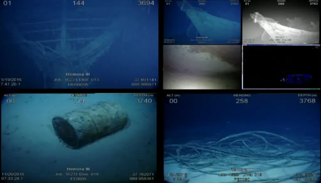
Moreover, the ATSB’s MH370 search overview page includes imagery from the search and notes that remotely operated vehicles were used to inspect man‑made objects discovered during the underwater search. That detail is a reminder that false positives are not rare; they are expected.
Consequently, any credible “find” will require an identification chain: imaging, configuration match, serial or manufacturing features where possible, and independent verification by investigators.
However, the deeper the object, the more difficult this becomes. At several thousand metres depth, even ROV operations are complex, weather‑dependent, and expensive.
Additionally, the recovery question looms behind identification. Locating a debris field is a milestone. Yet recovering recorders or key structure can demand a separate campaign, with heavy‑lift and specialised tooling.
For readers who enjoy systems thinking, Fliegerfaust has explored how aviation safety increasingly leans on redundancy and automation—an angle worth revisiting in Garmin Autoland and the push toward automated safety nets.
Search and rescue: The first 52 days and the shift from surface to seabed
Renewed MH370 search: why the “rescue” phase mattered even without survivors
Public memory often compresses MH370 into “it disappeared, then they searched the seabed.” In reality, the first response was a search and rescue (SAR) operation that unfolded in phases, responding to changing assumptions about the aircraft’s track.
Moreover, Malaysia’s official Safety Investigation Report states that the early effort involved Malaysia, Australia, and the People’s Republic of China, and it describes surface searches in the South China Sea, the Straits of Malacca, and the southern Indian Ocean. The report also notes that “the 52 days of the surface search involving aircraft and surface vessels covered an area of several million square kilometres,” and it adds that a sub‑surface search for the aircraft’s underwater locator beacons was conducted during the surface search.
Consequently, the “rescue” phase matters because it defined what could be ruled out early, and because it shaped the subsequent decision to commit to a sustained underwater effort.
However, it also exposed the human limits of ocean SAR. Even when you know roughly where to look, finding small debris on a dynamic sea surface is an exercise in probability, not certainty.
How the search moved: from airways to uncertainty
Meanwhile, the investigation record describes an evolving picture of the flight path. Public reports often emphasise the aircraft’s last known position near the Malaysia–Viet Nam flight information region boundary and the later focus on the Indian Ocean.
However, the SAR response did not “jump” instantly. It expanded and shifted as radar, communications, and later SATCOM metadata analysis informed the likely corridor. Those transitions carried operational consequences: different coordination centres, different SAR regions, and different asset mixes.
Additionally, Malaysia’s Safety Investigation Report includes extensive discussion of how SAR organisations and agreements function, including responsibilities for aeronautical SAR service within Malaysia’s search and rescue regions and coordination with neighbouring states. — Ministry of Transport Malaysia, Safety Investigation Report MH370 (9M‑MRO)
Consequently, MH370 became a stress test for regional SAR coordination in the air and at sea. It also became a stress test for the public’s understanding of what SAR can accomplish when the last known point is wrong.
The pinger search problem: underwater locator beacons and time
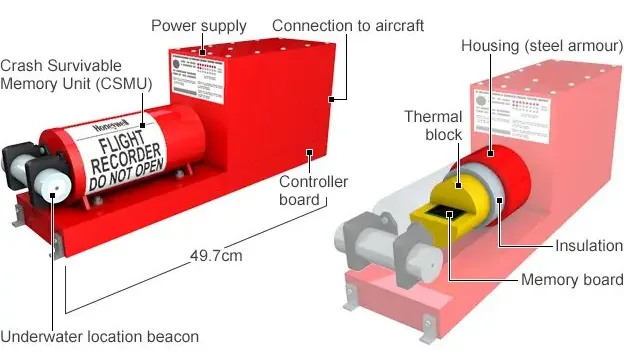
Notably, the phrase “pinger search” became shorthand in 2014. In technical terms, it was a sub-surface search for underwater locator beacons. They are attached to crash-survivable recorders, the so-called “black boxes.” In practice, those recorders are painted bright orange.
Moreover, Malaysia’s Safety Investigation Report confirms that a sub‑surface search for underwater locator beacons was conducted during the surface phase. That detail is vital because it shows planners were already thinking below the surface while surface searching continued.
However, beacon searches are constrained by time, distance, and acoustics. Batteries have finite endurance, and water conditions affect detection. In MH370’s case, the growing uncertainty about location meant the sub‑surface effort faced a moving target.
Consequently, once the SAR phase ended, the mission shifted toward a forensic, survey‑grade approach: map the seabed, scan it at high resolution, then verify contacts.
For a broader look at how governments define readiness and responsibilities in SAR, Fliegerfaust has examined why SAR requirements often surface in defence discussions, including how search‑and‑rescue readiness keeps showing up in procurement debates. The MH370 case is the civilian mirror of that same operational truth: you plan for the day you hope never comes.
Underwater search 2014–2017: How 120,000 square kilometres became 200,000
MH370 seabed search: the tripartite decision and the ATSB’s role
Notably, the underwater chapter began with a political and operational decision. The ATSB states that after the surface search concluded on April 28, 2014, Australia offered to continue leading search operations. It also states that on May 5, 2014, ministers from Malaysia, China, and Australia agreed to act as a Tripartite. Under that arrangement, Australia led the underwater search.
Consequently, the underwater search was not a single‑nation campaign. It was a coordinated effort with shared governance and technical coordination. However, Australia leading the search did not change investigation authority. Under International Civil Aviation Organization (ICAO) Annex 13, Malaysia remained responsible.
However, the underwater effort had to solve two parallel problems. First, it needed to define where to search. Second, it needed to execute a survey programme in a remote, harsh ocean environment.
Search systems and the bathymetry first principle
Meanwhile, the underwater search did not begin with high‑resolution sonar towing over a perfectly known seabed. It began with bathymetry because deep‑tow vehicles need safe, efficient routes close to the bottom.
Moreover, the Australian Transport Safety Bureau (ATSB) First Principles Review describes a phased approach. First, teams conduct bathymetric survey work before high‑resolution sonar. Next, they commence deep‑tow operations. The review says bathymetric surveying began in June 2014. It used hull‑mounted multibeam sonar on vessels including Fugro Equator and Zhu Kezhen.
Consequently, the underwater search produced two kinds of value. It created a high‑resolution “yes/no” answer for the defined search box, and it generated seabed maps of a poorly charted region.
However, those maps also revealed difficult terrain. In places, the seabed is rugged and steep, which reduces search efficiency and complicates sensor altitude control.
From 60,000 to 120,000 square kilometres—and beyond
Notably, early underwater planning assumed a smaller search box. The ATSB’s First Principles Review notes an initial target “up to 60,000 km².” Later, the review says the Tripartite expanded the area in April 2015. That decision increased the search zone to 120,000 km².
Moreover, the ATSB search overview says the ATSB‑led effort would cover over 120,000 square kilometres. It describes a remote area in the southern Indian Ocean.
Consequently, the programme became one of aviation’s largest systematic seabed searches. It was measured by coverage, not drama.
However, the outcome remained negative. The ATSB says Malaysia, Australia, and China suspended the search on January 17, 2017. They did so “until further credible evidence became available.”
Additionally, the ATSB explains a second search began on January 16, 2018. Ocean Infinity led that mission. It ended on May 29, 2018. Together, the searches covered close to 200,000 square kilometres of seafloor. Yet they did not locate the aircraft.
Drift, debris, and probabilities: Why the 7th arc still frames the hunt
MH370 hunt restarts: what “First Principles” actually concluded
The most influential official synthesis arrived before the ATSB‑led underwater programme ended. The ATSB convened the First Principles Review in Canberra on November 2–4, 2016. It brought together experts in satellite communications, aircraft performance, and flight operations. It also included specialists in sonar data, acoustic analysis, and oceanography.
Moreover, the review says updated satellite and drift analyses were consistent. It placed the likely impact close to the seventh arc, within about 25 nautical miles. Additionally, it bounded the best estimate between roughly 33°S and 36°S.
Consequently, that latitude band still guides many renewed MH370 search proposals. Even so, contractors may execute the work under commercial terms.
However, the report also stresses the sobering side of validation. It says confidence was high the previously searched underwater area did not contain the aircraft. Notably, it also flagged an area of about 25,000 km² as the highest‑probability wreckage zone.
MH370 wreckage search: what debris can and cannot tell investigators
Meanwhile, debris finds offered the only physical evidence outside of radar and SATCOM metadata. The ATSB’s MH370 search overview notes that debris aided the underwater search. It cites finds on Indian Ocean islands and East African coasts in 2015 and 2016. Additionally, it says drift modelling was performed by the Commonwealth Scientific and Industrial Research Organisation (CSIRO).
Moreover, CSIRO’s drift reports show how investigators treat debris evidence. They use it as a probabilistic constraint, not a single coordinate. In its Part II report, CSIRO describes improved modelling of the flaperon’s drift. That work increased confidence in the search area from the First Principles Review. However, it did not fundamentally change the most probable location estimate.
Additionally, the CSIRO Part I report describes the broader attempt to use drift modelling to inform the search and explicitly dedicates the work to the 239 people aboard MH370.
However, debris cannot replace recorder data. Even a confirmed flaperon and other fragments do not directly reveal cockpit actions, system status, or the final descent profile.
Consequently, the new mission’s biggest potential contribution is not just “closure.” It is technical certainty, which is what accident investigations are built to produce.
Why some questions are still open, by design
Notably, Malaysia’s Safety Investigation Report explains that the absence of the main wreckage, including the flight data recorder and cockpit voice recorder, limited the investigation’s ability to draw definitive conclusions. — Ministry of Transport Malaysia, Safety Investigation Report MH370 (9M‑MRO)
Moreover, the investigation’s structure reflects ICAO Annex 13’s philosophy: the goal is prevention, not blame. That distinction matters because it shapes what investigators publish, what they withhold, and how they word uncertainty.
However, the public does not live in the world of Annex 13. Families live in the world of unanswered questions. Operators live in the world of risk management. Regulators live in the world of standards and compliance.
Consequently, the social pressure to “solve MH370” is real, but it does not change the evidentiary threshold required to declare a finding.
For readers interested in how investigations translate into public process, Fliegerfaust has covered the mechanics of inquiry and documentation in how investigators use a docket to reconstruct an accident. MH370 is the rare case where the docket’s most important pages are still missing.
What happens if they find it: Recovery, investigation, and aviation safety
New MH370 search: what “found” would actually mean
Notably, a credible find would likely arrive in stages. First, the search team would identify a debris field or major structure with acoustic sensors. Next, they would verify the object visually with an ROV or high‑resolution camera payload. Finally, investigators would need to confirm identity using distinctive features and, where possible, serialised components.
Moreover, the ATSB has stated plainly why the find matters: “The ATSB acknowledges the importance of the aircraft being found, both for the families of those on board and for the interests of improving aviation safety.” — Australian Transport Safety Bureau, MH370 search overview
Consequently, confirmation would trigger both an investigative phase and a recovery planning phase. Those are not the same thing, and they may not happen on the same timeline.
Recorders, corrosion, and the time‑value of data
Meanwhile, the most valuable items on the seabed are the crash‑survivable recorders, but not because they hold a cinematic “last message.” They hold the only high‑fidelity record of systems, automation, and cockpit environment in the final minutes.
However, time is not neutral. Saltwater, pressure cycling, and biological growth all challenge recovery and preservation. That is why many investigators and families have pressed for urgency whenever a credible new box is proposed.
Additionally, the MH370 case has influenced the broader aviation debate about tracking and distress signalling. The industry has moved toward stronger global tracking standards since 2014, although implementation varies by operator and region.
For context on how safety and transparency pressures play out in politics, readers may find parallels in the policy stakes when safety data is incomplete. In both cases, incomplete information becomes a policy accelerant.
What recovery would look like—and what it might not deliver
Notably, recovery is not guaranteed even after a locate. Deep‑sea recovery often requires heavy‑lift and specialised tooling, and it can be constrained by weather windows and the condition of the debris field.
Moreover, recovery might prioritise recorders and key structure rather than an entire fuselage. That is not a lack of respect. It is a pragmatic approach to maximising safety value and evidentiary clarity.
However, even perfect recovery cannot rewrite the past. It can only improve our understanding of it, and that understanding may still leave uncomfortable ambiguities about intent and sequence.
Consequently, the most honest expectation for the public is this: a find can answer many questions, but it may not answer every question people want answered.
Conclusion: The search deserves transparency as much as endurance
Notably, MH370 remains the case that exposes the difference between what aviation can do and what aviation can prove. The world has the ability to scan a remote seabed at industrial scale. Yet the world still struggles to explain a modern widebody’s final hours without recorder data.
Moreover, the fact that MH370 search resumes again is a credit to sustained family advocacy, technical persistence, and the uncomfortable recognition that “suspension” is not the same as “resolution.” It is also a reminder that the most useful breakthroughs in this case have come from disciplined analysis, not from viral certainty.
However, the 2025–2026 mission also raises a hard question about public accountability. When a search is publicly funded, updates flow through governments. When a search runs under commercial terms, updates can become sporadic, curated, or delayed.
Additionally, live vessel tracking makes that tension sharper. It invites everyone to become an armchair operations officer, even though only the mission team knows what sensors are running, what contacts are being reviewed, and what has been ruled out.
The ocean keeps better secrets than most committees, and it does not leak to the press.
Ultimately, the case for this renewed MH370 search is strong. Even so, the case for transparent reporting is just as strong. If this mission ends without a find, will governments and contractors publish enough detail? Can independent experts verify what was truly searched? If not, how do we balance confidentiality with the public interest in aviation safety?
Leave your answers and comments below and on our Fliegerfaust Facebook page.
Sources
- Malaysia Ministry of Transport — Media Release: Resumption of MH370 search by Ocean Infinity in the southern Indian Ocean (December 3, 2025).
- Reuters — Hunt for missing flight MH370 to resume this month, Malaysia says (December 3, 2025).
- Associated Press — A Texas robotics company gets approval to search for MH370 in a new part of the Indian Ocean (March 25, 2025).
- Reuters — Malaysia agrees to resume search for missing MH370 plane (March 19, 2025).
- Reuters — MH370 search to resume soon, not the season, minister says (April 3, 2025).
- Airlive — For the past 24 hours, the vessel searching for MH370 has been moving at low speed in a very specific area (January 5, 2026).
- MH370‑CAPTION — Armada‑tracking (accessed January 2026).
- Australian Transport Safety Bureau — MH370 search overview (accessed January 2026).
- Australian Transport Safety Bureau — MH370 – First Principles Review (December 20, 2016).
- Ministry of Transport Malaysia — Safety Investigation Report MH370 (9M‑MRO) (July 2018).
- Commonwealth Scientific and Industrial Research Organisation — The search for MH370 and ocean surface drift – Part I (March 16, 2017).
- Commonwealth Scientific and Industrial Research Organisation — The search for MH370 and ocean surface drift – Part II (April 13, 2017).
For full details, please refer to our Disclaimer page.